


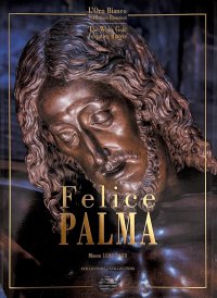
Felice Palma. Massa 1583-1625. Collezione / Collection.
Testi di Claudio Casini, Andrei Cristina, Ciarlo Nicola, Federici Fabrizio e Sara Ragni.
Testo Italiano e Inglese.
Pontedera, 2024; ril. in cofanetto, pp. 289, ill. b/n e col., tavv. b/n e col., cm 24,5x34.
(L'Oro Bianco. Straordinari Dimenticati. The White Gold Forgotten Masters).
prezzo di copertina: € 160.00
|

Libri compresi nell'offerta:
Felice Palma. Massa 1583-1625. Collezione / Collection.
Testi di Claudio Casini, Andrei Cristina, Ciarlo Nicola, Federici Fabrizio e Sara Ragni.
Testo Italiano e Inglese.
Pontedera, 2024; ril. in cofanetto, pp. 289, ill. b/n e col., tavv. b/n e col., cm 24,5x34.
(L'Oro Bianco. Straordinari Dimenticati. The White Gold Forgotten Masters).
OMAGGIO (prezzo di copertina: € 160.00)
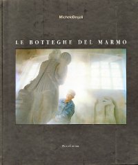
Le botteghe del marmo
Testo Italiano e Inglese.
Ospedaletto, 1992; ril., pp. 153, 10 ill. b/n, 60 ill. col., cm 24x29.
(Immagine).
OMAGGIO (prezzo di copertina: € 34.49)
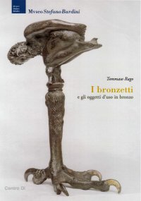
Museo Stefano Bardini. I Bronzetti e gli Oggetti d'Uso in Bronzo
A cura di Nesi A.
Firenze, 2009; br., pp. 191, 102 ill. b/n, 7 ill. col., cm 17x24,5.
(Museo Stefano Bardini).
OMAGGIO (prezzo di copertina: € 30.00)
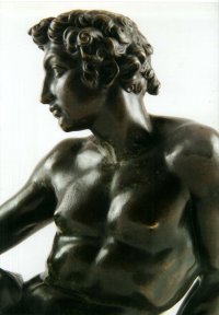
Bronzetti e Rilievi dal XV al XVIII Secolo
Bologna, 2015; 2 voll., ril. in cofanetto, pp. 729, ill., tavv. col., cm 21,5x30,5.
OMAGGIO (prezzo di copertina: € 90.00)
The Aerial Atlas of the Holy Land. Discover the Great Sites of History From the Air
Bowker John
Mitchell Beazley
Testo Inglese.
London, 2008; cartonato, pp. 256, ill. col., cm 24x28.
ISBN: 1-84533-340-3 - EAN13: 9781845333409
Testo in: 
Peso: 1.44 kg
The ancient lands of Galilee, Samaria, and Judea stand at a crossroads in western and eastern history. Sites such as Jerusalem, Bethlehem, and Nazareth exert a huge pull over millions of Christian and Muslim pilgrims, and countless others who dream of making such a journey themselves - fascinated by the area's unparalleled historical and religious heritage. "The Mitchell Beazley Aerial Atlas of the Holy Land" manages to do unique justice to the beauty, mystery, and grandeur of the region. It offers the reader a series of breathtaking aerial portraits and fascinating maps of 25 key sites dating from Biblical times to the Muslim Conquest, together with the landscape and sites that surround them. The result is a beautiful and useful reference work on one of history's most fascinating locations.

Pietro Bellotti Detto Canaletty. Un Vedutista Veneziano nella Francia dell'Ancien Régime
Luoghi Magici di Bologna. Vol. 1: la Piazza e i Suoi Simboli Segreti
Francesco Ruschi e l'«abundantia» barocca. Pittura e collezionismo tra Roma e la Serenissima

Il surrealismo piemontese. Lorenzo Alessandri, incisore e pittore. Ediz. illustrata
Conte e Mattarella. Sul palcoscenico e dietro le quinte del Quirinale. Un racconto sulle istituzioni